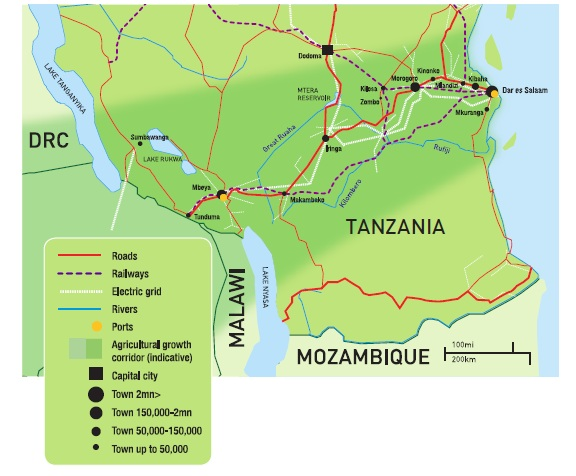
The Southern Agricultural Growth Corridor of Tanzania (SAGCOT) is an extensive agricultural development initiative designed to boost agricultural productivity, improve food security, and increase economic development across the southern region of Tanzania. The corridor stretches from Dar es Salaam on the eastern coast, through the central regions and extending to the western border of the country. Here’s a general outline of the corridor’s map:
- Eastern End (Starting Point): Dar es Salaam
- The corridor begins here, leveraging the port for export opportunities and logistics.
- Central Regions: Morogoro and Iringa
- These areas are central to the corridor’s agricultural activities, focusing on crop and horticulture production.
- Southern Highlands: Mbeya and Songwe
- This region is known for its favorable climate for growing a variety of crops including tea, coffee, and grains.
- Western End: Sumbawanga
- Extends to the western part of Tanzania, integrating areas with potential for further agricultural expansion.
- Linkages to Northern and Southern Regions:
- Although primarily focused on the central to southern stretch, SAGCOT also aims to enhance agricultural activities in the northern and southern regions indirectly through improved supply chains and infrastructure.
The corridor includes various infrastructure developments, such as road improvements, provision of irrigation schemes, and the establishment of agro-processing zones to facilitate the growth and efficiency of agricultural operations within the corridor.